

CURRENT BRIEFING
Here is the latest with the forecast for the heavy rain, strong wind and severe thunderstorm potential for today 3/16…
What Changed: The risk of damaging winds either within or outside of thunderstorms has diminished slightly, while the risk of isolated flooding due to heavy rain has increased slightly.
Strong southerly winds are expected along with potentially a few severe thunderstorms bringing locally damaging winds and heavy rain ahead of a cold front that will cross the region late today and tonight. It is possible that a line of convection (heavy showers) with the front tonight contains little or no lightning, but could produce some locally damaging wind gusts. A Wind Advisory may be needed for at least portions of our region for later today.
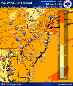
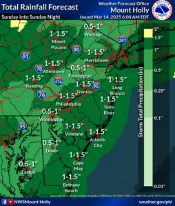
Hazardous Weather: Strong southerly wind gusts of 35-40 mph for land areas; sub-gale force gusts around 30 knots for the coastal waters/Delaware Bay… A few strong to severe thunderstorms may produce locally damaging winds (wind gusts up to 60 mph) and heavy rain (hourly rainfall rates of 1+ inches per hour for a time possible).
Locations affected: The entire region.
Timing: Strong winds outside of thunderstorms peak this afternoon into tonight. Heaviest rain tonight, with the greatest potential for some thunderstorms this evening.
Impacts: Strong winds outside of any thunderstorms, along with any severe thunderstorms, may cause some wind damage such as downed trees and power lines, resulting in localized power outages and road closures. Strong winds may also cause hazardous conditions for marine vessels. Locally heavy rain could cause some urban flooding during heavier hourly rainfall rates, resulting in localized road closures.
Confidence on occurrence: Confidence of strong winds and rainfall is high, however it is low regarding thunderstorm coverage and intensity.
PREVIOUS BRIEFING
A strong cold front will cross the region Sunday night, preceded by strong southerly winds and potentially some severe thunderstorms and locally heavy rain. It is possible that a line of convection (heavy showers) with the front Sunday night contains little or no lightning, but could produce locally damaging wind gusts.
Hazardous Weather: Strong southerly wind gusts of 35-45 mph for land areas, Gale-force gusts up to 40 knots for coastal waters; Damaging wind gusts with some thunderstorms (up to 60 mph possible) and heavy rain (hourly rainfall rates of 1+ inches per hour for a time possible).
Locations affected: The entire region.
Timing: Strong winds outside thunderstorms peak Sunday afternoon into early Sunday evening. Heaviest rain Sunday night, with the greatest potential for some thunderstorms Sunday evening.
Impacts: Strong winds outside of thunderstorms, along with any severe thunderstorms, may cause some wind damage such as downed trees and power lines, and create hazardous conditions for marine vessels. Locally heavy rain could cause some urban flooding.
Confidence on occurrence: Confidence of strong winds and rainfall is high, however confidence on the intensity, including thunderstorms, remains at moderate.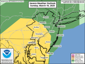

