WEATHER UPDATE: 6.22.26
An area of low pressure is expected to pass through the region today into tonight, bringing widespread showers and thunderstorms. Heavy rainfall and flash flooding will be possible along with the potential for scattered severe thunderstorms with damaging winds.
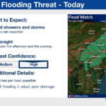
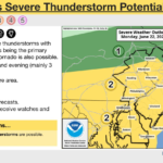
Changes from previous briefing: A flood watch has been issued for the I-95 corridor for today and tonight. There has also been an additional slight northward expansion in the slight risk for severe thunderstorms which now encompasses nearly the entire area.
Here are the key messages:
1. An area of low pressure is expected to bring widespread showers and thunderstorms to the region today into tonight.
2. Rainfall amounts could exceed 1 to 2 inches in an hour in spots, which could lead to flash flooding, particularly in urban areas.
3. The track of the low-pressure system through our area today will lead to the potential for scattered severe thunderstorms this afternoon into this evening with damaging winds the primary threat, however a tornado is also possible.
There has been increased agreement around the track of the low-pressure system moving through our area today into tonight. Due to the track of this system, there is now the risk of scattered severe thunderstorms across nearly the entire area. For the flash flooding risk, this includes much of the area with the greatest risk being urban areas.
For the latest forecast please visit www.weather.gov/phi
Call Us Today! 732-872-1224


