

 On January 20, 2026, the New Jersey Department of Environmental Protection (NJDEP) adopted the Resilient Environments and Landscapes (REAL) rule amendments. Effective July 20, 2027, all development within designated areas will be required to comply with these regulations. This will be in addition to the regulations established under the National Flood Insurance Program (NFIP) and Federal Emergency Management Agency (FEMA) for coastal flood hazard areas. These amendments will significantly impact development in flood prone, coastal and riverine areas of the State. The Borough of Highlands is particularly impacted due to the nature of its low-lying coastal flood zones and its proximity to the bay and ocean. At the heart of the REAL rules, are two base concepts: the Climate Adjusted Flood Elevation (CAFE) and the Inundation Risk Zone (IRZ).
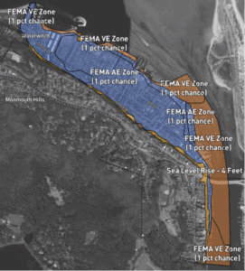
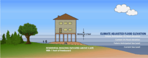
The Climate Adjusted Flood Elevation (CAFE) is a predicted limit of coastal flood hazard and storm-induced flooding exacerbated by sea-level rise by the year 2100. In tidal flood hazard areas, such as in Highlands, the REAL rule establishes a new flood elevation that adds four (4) feet to FEMA’s 100-year flood elevation, in effect increasing the elevation by which construction must be elevated to.
The Inundation Risk Zone (IRZ) is an area predicted to be permanently under water by 2100 due to sea level rise. Projects within the IRZ involving new residential developments, critical buildings and infrastructure (i.e. roadways and utilities), or substantial improvements to existing structures will need to meet more stringent risk assessments criteria. It is suggested that as sea levels rise, dry land adjacent to the current shoreline will become inundated more frequently and, in some cases, permanently. Current and proposed development in the IRZ, therefore, carries exceptional risk to life and property. Standards for development within the IRZ are found in N.J.A.C. 7:13-11.5, including a written “inundation risk assessment” that evaluates potential economic and other costs to current or future property owners, including government entities for activities on public land, associated with the projected present or future flooding and inundation risk.
Although here we present a number of Frequently Asked Questions, these regulations, and those of the Uniform Construction Code, FEMA, NFIP, ASCE 24, and other floodplain standards can be complicated and highly technical. We strongly recommend you consult a qualified, licensed design professional to help guide you through your project. Though the floodplain administrator and the construction official can help with general guidance and requirements of the regulations, public officials are prohibited from providing construction design advice.
MEETING VIDEOS
The REAL rules affect construction in four primary ways.
- It adds four (4) feet to the elevation at which certain types of construction must be elevated to
- It creates a higher risk flood area called the Inundation Risk Zone (IRZ), which requires that developers of certain projects within the zone obtain a NJDEP permit prior to filing for a construction permit.
- It increases the area of the flood hazard area outside the 100-year FEMA established flood hazard area. Flood insurance will not be required in this area, however, construction would need to comply with the Uniform Construction Code and other referenced floodplain regulations related to construction, such as elevating a structure.
- It requires the finish floor of the first habitable floor level to be one (1) foot above the Design Flood Elevation (DFE) in all non-coastal A zones. Previous regulations allowed for the finished floor to be at DFE.
Inundation Risk Zone standards apply to three types of activity:
Residential buildings
- All new, substantially damaged or substantially improved residential buildings
- One or more single-family homes or duplexes
- Residential subdivisions
- Multi-residence buildings such as hotels, condominiums, and apartments
Critical buildings
- Buildings defined as ASCE Flood Design Class 3 and 4
- New, substantially damaged or substantially improved schools, fire and police stations, medical facilities, correctional facilities, power generating stations, critical aviation facilities.
Critical infrastructure
- Public or private infrastructure (excluding buildings) that is critical for emergency response and recovery during and after a flood, or that poses a risk to public health, safety, and welfare should it be damaged or unable to perform its intended functions during or after a flood.
Activities EXEMPTED under N.J.A.C. 7:13-11.5(a)2 include:
- Mixed Use Commercial
- Industrial Structures
- Hospitality Structures
- Gaming Structures
- Recreational Structures
- Residential buildings: Repair and maintenance activities that do not alter the building’s footprint or increase its habitable area
- Critical buildings: Repair and maintenance activities that do not alter the building’s
- footprint or increase its habitable area
- Critical infrastructure
- Certain drainage improvements
- Safety or state of good repair improvements
- Any public transportation entity project that reached a preferred alternative or equivalent milestone prior to January 5, 2026
Please note that certain types of activities, although may be exempted from the Inundation Risk Zone rules, a project may need to comply with the substantial improvement or substantial damage regulations of the Uniform Construction Code.
Note: The term “Critical Building” is defined in N.J.A.C. 7:13-1.2 to mean a building that, based on its use and occupancy, is designated by the American Society of Engineers in their publication, “Flood Resistant Design and Construction (ASCE/SEI 24-14) that is a Flood Design Class 3 or Class 4 (ASCE 24-14, Table 1-1: Flood Design Class of Buildings & Structures)
See FAQ “What are Flood Design Class 3 and Class 4 Critical Buildings”
A “Critical Building” means a building that, based on its use and occupancy, is designated by the American Society of Engineers in their publication, “Flood Resistant Design and Construction (ASCE/SEI 24-14) that is a Flood Design Class 3 or Class 4
(From ASCE 24-14, Table 1-1: Flood Design Class of Buildings & Structures)
Flood Design Class 3 – Buildings and structures that pose a high risk to the public or significant disruption to the community should they be damaged, be unable to perform their intended functions after flooding, or fail due to flooding, and includes:
- buildings and structures in which a large number of persons may assemble in one place, such as theaters, lecture halls, concert halls, and religious institutions with large areas used for worship;
- museums;
- community centers and other recreational facilities;
- athletic facilities with seating for spectators;
- elementary schools, secondary schools, and buildings with college or adult education classrooms;
- jails, correctional facilities, and detention facilities;
- healthcare facilities not having surgery or emergency treatment capabilities;
- care facilities where residents have limited mobility or ability, including nursing homes, but not including care facilities for five or fewer persons;
- preschool and child care facilities not located in one- and two-family dwellings;
- buildings and structures associated with power generating stations, water and sewage treatment plants, telecommunication facilities, and other utilities that, if their operations were interrupted by a flood, would cause significant disruption in day-to-day life or significant economic losses in a community; and,
- buildings and other structures not included in Flood Design Class 4 (including, but not limited to, facilities that manufacture, process, handle, store, use, or dispose of such substances as hazardous fuels, hazardous chemicals, hazardous waste, or explosives) containing toxic or explosive substances where the quantity of the material exceeds a threshold quantity established by the authority having jurisdiction and is sufficient to pose a threat to the public if released.
Flood Design Class 4 – Buildings and structures that contain essential facilities and services necessary for emergency response and recovery, or that pose a substantial risk to the community at large in the event of failure, disruption of function, or damage by flooding, and includes:
- hospitals and health care facilities having surgery or emergency treatment facilities;
- fire, rescue, ambulance, and police stations and emergency vehicle garages;
- designated emergency shelters;
- designated emergency preparedness, communication, and operation centers and other facilities required for emergency response;
- power generating stations and other public utility facilities required in emergencies;
- critical aviation facilities, such as control towers, air traffic control centers, and hangars for aircraft used in emergency response;
- ancillary structures, such as communication towers, electrical substations, fuel or water storage tanks, or other structures necessary to allow continued functioning of a Flood Design Class 4 facility during and after an emergency; and,
- buildings and other structures (including, but not limited to, facilities that manufacture, process, handle, store, use, or dispose of such substances as hazardous fuels, hazardous chemicals, or hazardous waste) containing sufficient quantities of highly toxic substances where the quantity of the material exceeds a threshold quantity established by the authority having jurisdiction and is sufficient to pose a threat to the public if released.
Below is a list of the Highlands properties that are within the IRZ
| Block | Lot(s) |
| 7 | 1 thru 7 |
| 8 | 1 thru 2 |
| 39 | 1.02 thru 11 |
| 39 | 13 thru 17.01 |
| 40.01 | 21.01 thru 22.01 |
| 43 | 1 thru 11.03 |
| 44 | 1 thru 14.02 |
| 45 | 1 thru 7 |
| 46 | 1 thru 8 |
| 46 | 1 thru 8 |
| 47 | 1 thru 12 |
| 48 | 1 thru 7 |
| 49 | 1 thru 18 |
| 50 | 1 thru 4.01 |
| 51 | 1 thru 4 |
| 52 | 1 thru 20 |
| 53 | 1 thru 9 |
| 54 | 1 thru 24.02 |
| 55 | 1 thru 4.02 |
| 56 | 1 thru 6 |
| 56 | 10 & 18.01 |
| 57 | 1 thru 28 |
| 58 | 1 thru 26 |
| 59 | 2.01 thru 35 |
| 62 | 1 thru 9 |
| 63 | 1 thru 29 |
| 64 | 1 thru 28.01 |
| 65 | 1 thru 8 |
| 65 | 13 |
| 65 | 15 thru 25 |
| 65 | 30 thru 36 |
| 66 | 1 thru 15.01 |
| 67 | 1 & 1.01 |
| 68 | 3 |
| 69 | 1 thru 16 |
| 70 | 1 thru 17 |
| 71 | 1 thru 6 |
| 72 | 1 thru 7.01 |
| 72 | 1 thru 8 |
| 72 | 11.01 thru 41.01 |
| 73 | 2 thru 5 |
| 74 | 1 thru 9 |
| 75 | 1 thru 18 |
| 76 | 1 thru 17 |
| 77 | 2.01 thru 17 |
| 78 | 1 thru 16.01 |
| 79 | 1 thru 19 |
| 80 | 1 thru 22 |
| 81 | 1 thru 12 |
| 82 | 1.01 thru 6.01 |
| 83 | 1 thru 13 |
| 84 | 2.01 |
| 85 | 1.01 thru 6.01 |
| 86 | 1 thru 4 |
| 87 | 1 thru 4 |
| 88 | 1.01 thru 5 |
| 89 | 1 thru 13.01 |
| 90 | 1.01 thru 16 |
| 91 | 1.01 thru 13.03 |
| 92 | 1 thru 11 |
| 93 | 1 thru 15,01 |
| 94 | 1 thru 15.03 |
| 95 | 1 |
| 96 | 1 |
| 96.01 | 2.01 & 3 |
| 97 | 1 thru 14.01 |
| 98 | 1 thru 14 |
| 99 | 1 thru 13 |
| 99 | 14 (Address No’s 13, 15, & 17 only) |
| 99 | 15 thru 31.01 |
| 100 | 1 thru 26 |
Before any regulated activity may be undertaken in a regulated area, an authorization or permit is required under the Flood Hazard Area Control Act Rules.
It is the responsibility of the owner/applicant to contact NJDEP to verify, and if necessary, apply for and receive all required permits prior to the start of any project within a regulated area. NJDEP permits, if required, must be obtained prior to the filing of a construction permit.
The NJDEP has six (6) different types of authorizations and permits. They are:
- Permits-by-registration (N.J.A.C. 7:13-7)
- General permits-by-certification (N.J.A.C. 7:13-8)
- General permits (N.J.A.C. 7:13-9)
- Individual permits
- Emergency authorizations
- Coastal permits
We address only the first three, since they are within the scope of this discussion.
Permits-by-registration are adopted to cover certain activities that are minor in scope with little or no impact on flooding and the environment. The Flood Hazard Area Control Act Rules include 30 permits-by-registration, described at N.J.A.C. 7:13-7. Since no prior written authorization is required before undertaking eligible activities, each permit-by-registration is adopted with clearly defined limits provided at N.J.A.C. 7:13-7 as well as general conditions that must be met for each activity pursuant to N.J.A.C. 7:13-6.7. If the activity cannot meet those limits, it is not approved under the permit-by-registration.
Prior to undertaking an activity authorized by a permit-by-registration, the owner of the site or a designated agent such as the person performing the work must register with NJDEP through the NJDEP Online Business Portal. The registrant must provide a copy of the documentation provided by NJDEP to both the Highlands Construction Official and Floodplain Administrator.
GENERAL PERMITS-BY-CERTIFICATION
General permits-by-certification are instant, online authorizations available for certain regulated activities that are more complex than activities that are eligible for a permit-by-registration and therefore require authorization through NJDEP’s electronic permitting system before they can be undertaken. However, like permits-by-registration, they include specific limitations, which allow the automated issuance of an approval or rejection. There is no need for a case-by-case evaluation of whether the activity meets the specifically defined conditions of a general permit-by-certification because a licensed professional engineer or registered architect must certify that it does.
The online process additionally provides the Department with a record of the proposed activity, including the location and extent of the regulated activity and the applicant’s and property owner’s names, addresses, and contact information. The Flood Hazard Area Control Act Rules include 15 general permits-by-certification, described at N.J.A.C. 7:13-8.
Before beginning the online application process for this type of NJDEP permit, the applicant must ensure that all application requirements have been met, including the requirement to provide public notice (see N.J.A.C. 7:13-19 for the public notice requirements).
Like permits-by-registration and general permits-by-certification, general permits are adopted or promulgated under the Flood Hazard Area Control Act Rules. However, unlike permits-by-registration and general permits-by-certification, NJDEP staff review the proposed activity to ensure that the activity meets the requirements of the specific general permit under which authorization is sought. After an activity is found to comply with a general permit, a written authorization is issued under that permit. The Flood Hazard Area Control Act Rules include general permits for 12 activities, which are described at N.J.A.C. 7:13-9. Prior to undertaking activities authorized under a general permit, the applicant must submit an application to NJDEP.
If it is unclear whether a particular activity is regulated under the Flood Hazard Area Control Act rules, a person may request an applicability determination, which is an optional service NJDEP provides to anyone who wants a written determination of whether or not a flood hazard area permit or authorization is necessary. Applicability determinations are recommended when there is uncertainty as to whether an activity is regulated to avoid unintentionally undertaking unauthorized regulated activities and incurring potential liability. There is no fee for applicability determinations, and the procedure for requesting an applicability determination is provided at N.J.A.C. 7:13-2.6.
CLICK HERE TO DOWNLOAD AN APPLICABILITY DETERMINATION CHECKLIST
EXEMPT ACTIVITIES UNDER N.J.A.C. 7:13-2.5(a)
There are 14 classes of activities which, due to their limited scope and de minimis impact to flooding and the environment, do not require authorization under the Flood Hazard Area Control Act Rules. Each class of activities is qualified by conditions necessary to ensure that the activity is properly undertaken.
- Normal property maintenance, including the clearing, cutting, and/or removal of riparian zone vegetation, which is necessary to service, maintain, or ensure the continued safe use of a lawfully existing structure, easement, right-of-way, field, lawn, park, and/or garden.
- Repair of a lawfully existing structure.
- Removal of accumulated sediment and debris from a regulated water by hand.
- Removal of a major obstruction from a regulated water with machinery, such as a fallen tree, abandoned vehicle, furniture, and other large debris.
- Exploratory site investigation, including general land surveying, the installation of monitoring wells, and geotechnical and archeological investigation, such as undertaking soil borings or excavation for the purpose of obtaining information on subsurface conditions, determining the presence or extent of groundwater or contamination in subsurface, or obtaining seismic information.
- Storage of unsecured material.
- Placement, storage, or processing of hazardous waste and/or substances, solid waste, or recyclable materials, at a lawfully existing facility.
- Continuation of lawfully existing agricultural activities, such as grazing, harvesting, horticulture, irrigation, planting, tilling, viticulture, and watering on land that is actively farmed, and/or the commencement of new agricultural activities on land that is not actively farmed.
- Repair, maintenance, and/or dredging of the channel and/or embankments of the Delaware and Raritan Canal.
- Placement of one or more utility poles, such as telephone and electric poles, or structures on poles intended to facilitate travel safety along a public roadway or railroad, such as overhead signs, variable message signs, streetlights, and traffic signal equipment.
- Milling, repaving, repair, and/or resurfacing of lawfully existing pavement.
- The construction, replacement, repair, or removal of any dam that does not serve as a component of a stormwater management basin, as well as any regulated activity performed in association with the removal of a dam that does not serve as a component of a stormwater management basin.
- The placement or underground jacking of one or more underground utility lines.
- The removal of any lawfully existing fill or structure.
The New Jersey Department of environmental protection Watershed & Land Management published the Flood Hazard Area Control Act Rules Technical Manual (January 2026), which provides detailed information concerning the Flood Hazard Area Control Act Rules.
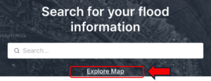
The CAFE layer is available on our public facing Forerunner Floodplain Map.
STEP 1. CLICK EXPLORE MAP
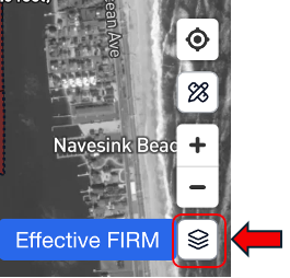
STEP 2. ON THE BOTTOM RIGHT OF MAP CLICK THE LAYERS BUTTON TO OPEN
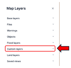
STEP 3. CLICK CUSTOM LAYERS TO EXPAND
STEP 4. TOGGLE THE TIDAL ADJUSTED FLOOD ELEVATION BUTTON TO ON
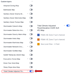
YOU WILL NOW SEE THE TIDAL CLIMATE ADJUSTED FLOOD ELEVATION (CAFE) & SEA LEVEL RISE (SLR) 4 ft MAP
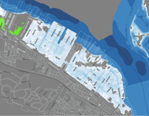
The Inundation Risk Zone layer is available on our public facing Forerunner Floodplain Map.
STEP 1. CLICK EXPLORE MAP
STEP 2. ON THE BOTTOM RIGHT OF MAP CLICK THE LAYERS BUTTON TO OPEN
STEP 3. CLICK BASE LAYERS TO EXPAND
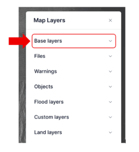
STEP 4. TOGGLE THE NJDEP INUNDATION RISK ZONE (IRZ) BUTTON TO ON
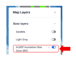
YOU WILL NOW SEE THE INUNDATION RISK ZONE, WHICH IS HIGHLIGHTED IN WHITE and ALL SHADES OF BLUE
You will be required to coordinate with multiple agencies, departments, and officials, depending on the complexity of your project. While the NJDEP is responsible for the permitting aspects of the REAL rules, as well as floodplain, coastal and wetlands development, the Borough Construction Official, Floodplain Administrator, and Community Rating System (CRS) Coordinator is responsible for the NFIP, FEMA and UCC aspects of development.
If you own an existing single-family home in a floodplain, or an Inundation Risk Zone, you are not required to elevate your home unless the home is considered a substantial improvement or a substantial damage.
The first habitable floor (not grade level) in a floodplain for a single-family home must now be elevated to the new Coastal Area Flood Elevation (CAFE) standards, which means that the elevation of the first habitable floor level is calculated by adding the Base Flood Elevation (BFE) to the CAFE of 4 feet plus 1 foot Freeboard.
For example, let’s assume the home is in an AE zone where the BFE is 11. To find the minimum elevation the calculation would be as follows:
BFE + CAFE + Freeboard (note, Highlands has a Freeboard of 1 foot)
11 + 4 + 1= 16 Elevation
That does not mean the home must be elevated 16 feet above the ground. To find out how high above adjacent grade (ground) the home must be elevated to you would deduct the elevation of the ground. For example, the average elevation of the ground on Bay Avenue is roughly 5 feet. You would deduct this amount from the elevation of 16, which would give you an indication that the first habitable floor level must sit roughly 11 feet above ground. Of course, the only way to confirm elevations is by hiring a licensed land surveyor and have an Elevation Certificate prepared.
If the home is in an A or Coastal A zone, the lowest structural member would need to be elevated above the BFE + CAFE + Freeboard.
There is no need to raise your home if no work is being performed. An existing home may remain at its current elevation. However, if your construction project meets the definition of a “substantial improvement” or “substantial damage”, you will be required to elevate your home to the new elevation standards established by the REAL rules. Additionally, the Uniform Construction Code requires all existing homes undergoing a substantial improvement or that have been substantially damaged be made compliant with the current and most stringent floodplain regulations. Remember, “substantial improvement” and “substantial damage” means that a construction project has exceeded 50% of the improved value of the property or that the total cost of work performed in the prior 10 years exceeds that 50% threshold.
Although you are permitted to install an elevator in a single-family home, they are not required.
The REAL rules will not in any way affect FEMA flood mapping or require people to obtain flood insurance. Federal flood insurance rates are set by FEMA’s Flood Insurance Rate Maps. Only FEMA can amend or alter these maps.
The State does not require development to have flood insurance. Individuals are generally required to obtain flood insurance only if:
- A building is located within a FEMA-mapped 100-year floodplain, (which is unchanged by the REAL rules);
- There is a mortgage on the building; and
- The lender requires flood insurance to protect their investment.
While the REAL rules do not alter the need for or cost of flood insurance, the rule does create a larger floodplain within which development is required to obtain a NJDEP permit and conform to the proposed new construction standards.
The substantial improvement and substantial damage rules, commonly referred to as the 50% rule, is affected to the extent that a home will now need to be elevated an additional 4 feet higher than it was prior to the REAL rules coming into effect. The 50% rule requires that if a structure undergoes a substantial improvement or damage that exceeds 50% of the improved value of the property, the structure must be made compliant with the most recent floodplain regulations, including those adopted under the REAL rules.
“Substantial improvement” means any reconstruction, rehabilitation, addition, or other improvement of a structure, the cost of which, including the cumulative cost of all improvements made to the structure for the prior ten (10) years, equals or exceeds 50% of the market value of the structure as determined before the start of construction of the improvement. This term includes structures that have sustained substantial damage regardless of the actual repair work performed. Substantial improvement does not include:
- Any project for improvement of a structure to correct existing violations of State or local health, sanitary or safety code specifications which have been identified by the local code enforcement officer and which are the minimum necessary to assure safe living conditions; or
- Any alteration of a building designated by the State as an historic structure, provided that the alteration will not preclude the structure’s continued designation as an historic structure.
Elevations of a home, including structural members, mechanical and electrical equipment, and adjacent grade, can only be done by way of a licensed land surveyor, and documenting such elevations on an Elevation Certificate.
All Applications for development not yet deemed complete or approved by July 20, 2026, will need to comply with the new REAL rules.
The REAL rules can potentially impact the sale of your home in several ways. Below is a list of some factors to consider:
- Mandatory Disclosure: Since March 2024, you must disclose if your property is in a FEMA flood zone and reveal any past flood or water damage, including the date, extent, and repairs.
- Stricter Building Standards: The REAL rules require new or “substantially improved” homes (those with costs of repairs exceeding 50% of the market value) to be elevated four feet above the base flood elevation. If your home requires significant renovations to sell, these costs may be higher.
- Buyer Scrutiny & Value: Homes in coastal areas may face, from, or need, higher insurance premiums. Conversely, already elevated or compliant homes may be more attractive to buyers looking for “future-ready” properties.
- Development Limitations: The rules impose stricter standards on development in coastal inundation zones, which could affect the marketability of vacant land or the ability to expand existing homes.
- Timing: Projects with applications deemed complete within 180 days of the rules’ effective date (by roughly July 20, 2026) may be exempt from the strictest new requirements.
- Compliance: Homes made compliant with the REAL rules will present a buyer. There’s an opportunity to purchase a home that is already compliant with the floodplain regulations.
New Jersey’s Resilient Environments and Landscapes (REAL) rules are designed to protect against flood risks, but they are not expected to directly reduce insurance premiums. Federal flood insurance rates are set by FEMA’s Flood Insurance Rate Maps (FIRM). Only FEMA can amend or alter these maps.
In accordance with N.J.A.C. 7:13-11.5(a)2, mixed use commercial, commonly understood as residential over commercial space is subject to the elevation requirements of the REAL rules. However, it is not subject to the NJDEP permitting requirements if the development is in the IRZ. It is subject to NJDEP permitting requirements if the development is in other protected areas such as CAFRA and Wetlands. NJDEP should be contacted to confirm exemption.
Please note that certain types of activities, although may be exempted from the Inundation Risk Zone rules, a project may need to comply with the substantial improvement or substantial damage regulations of the Uniform Construction Code.
The first habitable floor (not grade level) in a floodplain for a mixed-use structure must now be elevated to the new CAFE standards, which means that the elevation of the first habitable floor level is calculated by adding the Base Flood Elevation (BFE) to the CAFE elevation of 4 feet plus 1 foot Freeboard. For example, let’s assume the structure is in an AE zone where the BFE is 11. To find the minimum elevation the calculation would be as follows:
BFE + CAFE + Freeboard (note, Highlands has a Freeboard of 1 foot)
11 + 4 + 1= Elevation 16
That does not mean the structure must be elevated 16 feet above the ground. To find out how high above adjacent grade (ground) the home must be elevated to you would deduct the elevation of the ground. For example, the average elevation of the ground on Bay Avenue is roughly 5 feet. You would deduct this amount from the elevation of 16, which would give you an indication that the first habitable floor level will sit roughly 11 feet above ground. Of course, the only way to confirm elevations is by hiring a licensed land surveyor and have an Elevation Certificate prepared.
If the structure is in an A or Coastal A zone, the lowest structural member would need to be elevated above the BFE + CAFE + Freeboard.
Only residential structures are permitted to be wet flood proofed, meaning water is permitted to flow into the lower grade level. However, commercial structures are not permitted to be wet flood proofed, but they are permitted to be dry flood proofed, which means keeping the water out of the structure. Therefore, a dry flood proofed mixed-use building is permitted to have the lowest finished floor within the floodplain at grade level.
However, dry flood proofed structures must be designed and built to withstand the hydrostatic pressure of flood waters up to the level of the Design Flood Elevation. There are significant and complex regulations that must be followed for structures of this nature, and they require substantial planning and specialized construction techniques. Dry flood proofing, although available as an option, is not always recommended in a floodplain.
There is no need to raise your building if no work is being performed. An existing business may remain at its current elevation. However, if your construction project meets the definition of a “substantial improvement” or “substantial damage”, you will be required to elevate your structure to the new elevation standards established by the REAL rules. As an alternative, you may dry flood proof the lower floor, although it should be noted that dry flood proofing an existing building not originally designed for the hydrostatic pressure of floodwaters is not likely to be feasible.
All Applications for commercial development not yet deemed complete or approved by July 20, 2026, will need to comply with the new REAL rules.
The CAFE regulations are in addition to the floodplain regulations established under FEMA, NFIP, Municipal Ordinance, and the Uniform Construction Code.
Yes, structures that are not compliant with the CAFE regulations when it is deemed that compliance is required due to substantial improvement or damage will negatively impact a Community Rating System (CRS) score. Since the purpose of the CRS score is to obtain an insurance discount through the NFIP for floodplain property owners, it is incumbent on all municipal officials to ensure that construction within floodplains is compliant with all adopted regulations.
Yes, the REAL rules apply to all designated flood hazard areas of all municipalities throughout the State of New Jersey. Enforcement is compulsory under Title 7 of the New Jersey Administrative Code and Uniform Construction Code.
A construction project will not be approved if it is not compliant with CAFE regulations, as well as the current municipal floodplain regulations established by ordinance. All construction within designated flood hazard areas will be required to comply with the current FEMA Base Flood Elevation +1-foot Freeboard + 4-foot CAFE.
The CAFE regulations require an additional 4 feet elevation above the current FEMA Base Flood Elevation +1 foot Freeboard. The area below the elevated structure can only be used for parking, storage, or access to the other levels, unless it is dry flood proofed.